Welcome to the Northern Shores of Ore!

We will have info here for residents of the Northern Shores.
We will be hosting a Community-Wide Flood Discussion for Ore Lake and surrounding communities on Thursday, July 8, 2021 from 6:30-7:30pm. During this meeting, community members will have a chance to share their experiences with flooding, and their goals for our work with partner scientists. For health and safety concerns, the meeting with be held via Zoom. You will need to register in advance for the meeting: https://msu.zoom.us/meeting/register/tJIvfu2prjopGtQ2ONNMBWJToV87OAL6GOc4
After registering, you will receive a confirmation email containing information about joining the meeting. You should also make sure you have Zoom downloaded to your computer, if you are joining by computer. You can download Zoom by going to https://zoom.us/download.
Residents Working Against Huron River Flooding engage in creative ways to minimize flooding along the Huron River and surrounding areas (e.g., Ore Lake). We also share information about resources for raising structures and about upcoming flooding events.
Here is some information on Invasive Species in our area.
Information about our trash collection service, GFL, is here - Attach:GFLContract.pdf
Important The speed limit on both Branch and Mohican is 15 MPH !! Please be mindful of your speed and respectful of your neighbors. We have young children in the neighborhood, along with walkers, runners, bicyclists, and dog walkers using our roads. With no sidewalks we all have to share the same road. Pass along a gentle reminder to those who may be new to the neighborhood, and to your guests and vistors.
We have information about the recent PFAS contamination in the Huron River and Ore Lake here: PFAS Info
You can find some Water Level information here.
Here is a document from the February 2020 flood committee meeting. It includes documents from the USGS/USACE study. http://cms5.revize.com/revize/hamburgtownship/Boardroom/Flood%20Prevention%20Committee/2020/agendas&infopackets/02242020%20-%20Proposed%20Agenda%20-%20FLOOD%20HAZARD%20PREVENTION%20COMMITTEE.pdf
USGS Flood Inundation Mapper https://fim.wim.usgs.gov/fim/ Zoom in to the State of Michigan and find the triangle for the gage station area at Hamburg Road bridge on the Huron River, and move up and down the river towards Ore Lake/Little Ore Lake. Use the zooming tool in the pop up box to reveal projected flood levels around the area.
If you have any additional information that you think should be on this site, please let us know.
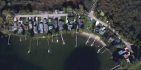 Northern Shores of Ore